
X. Bezirk topographic map
Interactive map
Click on the map to display elevation.
About this map
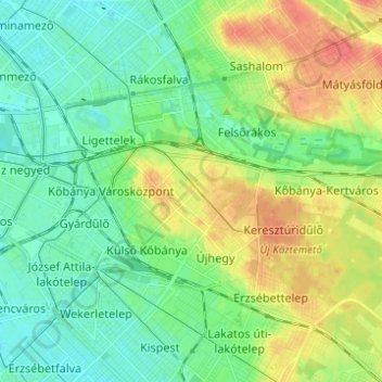
Name: X. Bezirk topographic map, elevation, terrain.
Location: X. Bezirk, Budapest, Mittelungarn, Ungarn (47.45817 19.09867 47.50673 19.22166)
Average elevation: 423 ft
Minimum elevation: 367 ft
Maximum elevation: 518 ft
Other topographic maps
Click on a map to view its topography, its elevation and its terrain.
Gellértberg
Gellértberg, Budapest, XI. Bezirk, Mittelungarn, 1114, Ungarn
Average elevation: 413 ft
Gottesberg
Gottesberg, XII. Bezirk, Budapest, XII. Bezirk, Mittelungarn, 1125, Ungarn
Average elevation: 810 ft
Johannisberg
Johannisberg, XII. Bezirk, Budapest, Mittelungarn, 1021, Ungarn
Average elevation: 1,125 ft
Galgenberg
Galgenberg, XI. Bezirk, Budapest, Mittelungarn, Ungarn
Average elevation: 427 ft
Johannisberg
Johannisberg, XII. Bezirk, Budapest, Mittelungarn, Ungarn
Average elevation: 1,093 ft