
Greenwich Harbor topographic map
Interactive map
Click on the map to display elevation.
About this map
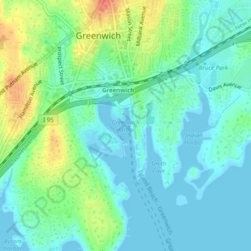
Name: Greenwich Harbor topographic map, elevation, terrain.
Average elevation: 46 ft
Minimum elevation: -7 ft
Maximum elevation: 161 ft
Other topographic maps
Click on a map to view its topography, its elevation and its terrain.
Audubon Greenwich
USA > Connecticut > Greenwich
Audubon Greenwich, John Street, Greenwich, Fairfield, Connecticut, 10504:10506, USA
Average elevation: 433 ft
Island Beach
USA > Connecticut > Greenwich
Island Beach, Greenwich, Fairfield, Connecticut, USA
Average elevation: 0 ft
Red Rock
USA > Connecticut > Greenwich
Red Rock, Greenwich, Fairfield, Connecticut, 06876, USA
Average elevation: 184 ft
Pelican Island
USA > Connecticut > Greenwich
Pelican Island, Greenwich, Fairfield, Connecticut, USA
Average elevation: 3 ft