
Mälaren topographic map
Interactive map
Click on the map to display elevation.
About this map
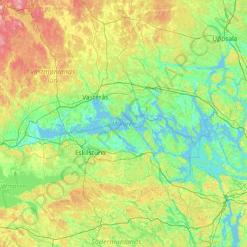
Name: Mälaren topographic map, elevation, terrain.
Location: Mälaren, Region Svealand, Sweden (59.19349 16.00058 59.79584 18.07813)
Average elevation: 138 ft
Minimum elevation: -10 ft
Maximum elevation: 735 ft
Other topographic maps
Click on a map to view its topography, its elevation and its terrain.
Trosa kommun
Trosa kommun, Södermanland County, Region Svealand, Sweden
Average elevation: 23 ft
Selaön
Selaön, Strängnäs kommun, Södermanland County, Region Svealand, 64596, Sweden
Average elevation: 36 ft
Jönåker
Sweden > Södermanland County > Jönåker
Jönåker, Nyköpings kommun, Södermanland County, Region Svealand, Sweden
Average elevation: 89 ft
Öster-Malma
Öster-Malma, Nyköpings kommun, Södermanland County, Region Svealand, Sweden
Average elevation: 128 ft
Katrineholm
Sweden > Södermanland County > Katrineholm
Katrineholm, Katrineholms kommun, Södermanland County, Region Svealand, 641 30, Sweden
Average elevation: 157 ft
Svärdbro
Sweden > Södermanland County > Svärdbro
Svärdbro, Nyköping, Södermanland County, Region Svealand, 61174, Sweden
Average elevation: 92 ft
Tystberga
Sweden > Södermanland County > Tystberga
Tystberga, Nyköping, Södermanland County, Region Svealand, 611 74, Sweden
Average elevation: 89 ft
Skogsbyås
Sweden > Södermanland County > Bråten
Skogsbyås, Bråten, Nyköping, Södermanland County, Region Svealand, Sweden
Average elevation: 266 ft
Oxelösund
Sweden > Södermanland County > Oxelösund
Oxelösund, Oxelösunds kommun, Sveriges Landskap, Södermanland County, Region Svealand, 61381, Sweden
Average elevation: 13 ft