
Worley topographic map
Interactive map
Click on the map to display elevation.
About this map
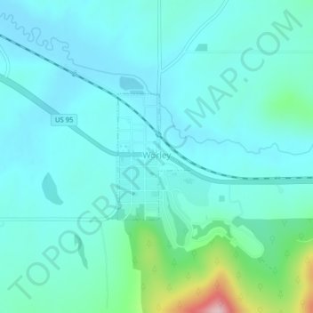
Name: Worley topographic map, elevation, terrain.
Location: Worley, Kootenai County, Idaho, United States (47.39512 -116.92215 47.40602 -116.91275)
Average elevation: 2,723 ft
Minimum elevation: 2,595 ft
Maximum elevation: 3,379 ft
Worley is located at 47°23′57″N 116°55′10″W / 47.39917°N 116.91944°W / 47.39917; -116.91944 (47.399124, -116.919410), at an elevation of 2,661 feet (811 m) above sea level.
Other topographic maps
Click on a map to view its topography, its elevation and its terrain.
Post Falls
United States > Idaho > Kootenai County
Post Falls, Kootenai County, Idaho, 83854, United States
Average elevation: 2,329 ft
Coeur d'Alene
United States > Idaho > Kootenai County
Coeur d'Alene, Kootenai County, Idaho, 83815, United States
Average elevation: 2,359 ft
Hauser
United States > Idaho > Kootenai County
Hauser, Kootenai County, Idaho, United States
Average elevation: 2,336 ft
Bayview
United States > Idaho > Kootenai County
Bayview, Kootenai County, Idaho, United States
Average elevation: 2,405 ft
Farragut State Park
United States > Idaho > Kootenai County > Bayview
Farragut State Park, Bayview, Kootenai County, Idaho, United States
Average elevation: 2,372 ft
Fernan Saddle
United States > Idaho > Kootenai County
Fernan Saddle, Kootenai County, Idaho, United States
Average elevation: 3,940 ft
Lake Coeur d'Alene
United States > Idaho > Kootenai County > Harrison
Lake Coeur d'Alene, Harrison, Kootenai County, Idaho, United States
Average elevation: 2,713 ft
Fernan Lake
United States > Idaho > Kootenai County > Coeur d'Alene
Fernan Lake, Coeur d'Alene, Kootenai County, Idaho, United States
Average elevation: 2,438 ft
Hayden
United States > Idaho > Kootenai County
Hayden, Kootenai County, Idaho, United States
Average elevation: 2,326 ft
Cataldo
United States > Idaho > Kootenai County
Cataldo, Kootenai County, Idaho, 83839, United States
Average elevation: 2,402 ft
Athol
United States > Idaho > Kootenai County
Athol, Kootenai County, Idaho, United States
Average elevation: 2,405 ft
Bellgrove
United States > Idaho > Kootenai County
Bellgrove, Kootenai County, Idaho, United States
Average elevation: 2,631 ft
Silver Sands Beach
United States > Idaho > Kootenai County
Silver Sands Beach, Kootenai County, Idaho, United States
Average elevation: 2,513 ft
Hauser Lake
United States > Idaho > Kootenai County > Hauser
Hauser Lake, Hauser, Kootenai County, Idaho, United States
Average elevation: 2,283 ft
Hayden
United States > Idaho > Kootenai County
Hayden, Kootenai County, Idaho, 83835, United States
Average elevation: 2,352 ft
Cherry Hill
United States > Idaho > Kootenai County > Coeur d'Alene
Cherry Hill, Coeur d'Alene, Kootenai County, Idaho, 83815, United States
Average elevation: 2,323 ft
Dalton Gardens
United States > Idaho > Kootenai County
Dalton Gardens, Kootenai County, Idaho, United States
Average elevation: 2,287 ft
Rathdrum
United States > Idaho > Kootenai County
Rathdrum, Kootenai County, Idaho, United States
Average elevation: 2,300 ft
Spirit Lake
United States > Idaho > Kootenai County
Spirit Lake, Kootenai County, Idaho, 83869, United States
Average elevation: 2,559 ft
Harrison
United States > Idaho > Kootenai County
Harrison, Kootenai County, Idaho, United States
Average elevation: 2,444 ft