
Ironwood topographic map
Interactive map
Click on the map to display elevation.
About this map
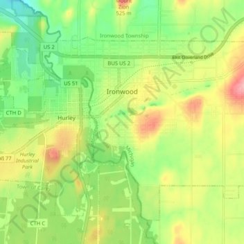
Name: Ironwood topographic map, elevation, terrain.
Location: Ironwood, Gogebic County, Michigan, United States (46.42665 -90.19361 46.47068 -90.11415)
Average elevation: 1,503 ft
Minimum elevation: 1,332 ft
Maximum elevation: 1,719 ft
In the early 1960s, the U.S. Air Force established a Strategic Air Command (SAC) Radar Bomb Scoring site atop Norrie hill to track and score high altitude and treetop level simulated bomb runs by B-52s and B-47s on targets in the Ironwood area. A monument is erected south of Hurley, Wisconsin to remember those crew members killed in two B-47 low level runs. The site was moved to Charlevoix, Michigan in the mid-1960s.
Other topographic maps
Click on a map to view its topography, its elevation and its terrain.
Wakefield
United States > Michigan > Gogebic County
Wakefield, Gogebic County, Michigan, 49968, United States
Average elevation: 1,509 ft
Marenisco
United States > Michigan > Gogebic County
Marenisco, Marenisco Township, Gogebic County, Michigan, 49947, United States
Average elevation: 1,565 ft
Ramsay
United States > Michigan > Gogebic County
Ramsay, Bessemer Township, Gogebic County, Michigan, 49959, United States
Average elevation: 1,532 ft
Puritan
United States > Michigan > Gogebic County
Puritan, Bessemer Township, Gogebic County, Michigan, 49911, United States
Average elevation: 1,519 ft
Ironwood Township
United States > Michigan > Gogebic County
Ironwood Township, Gogebic County, Michigan, United States
Average elevation: 1,020 ft
Copper Peak
United States > Michigan > Gogebic County
Copper Peak, Ironwood Township, Gogebic County, Michigan, United States
Average elevation: 1,168 ft
Fishhawk Lake
United States > Michigan > Gogebic County
Fishhawk Lake, Watersmeet Township, Gogebic County, Michigan, United States
Average elevation: 1,696 ft
Watersmeet
United States > Michigan > Gogebic County
Watersmeet, Watersmeet Township, Gogebic County, Michigan, 49969, United States
Average elevation: 1,637 ft
Bessemer
United States > Michigan > Gogebic County
Bessemer, Gogebic County, Michigan, 49911, United States
Average elevation: 1,503 ft