
Brauneberg topographic map
Interactive map
Click on the map to display elevation.
About this map
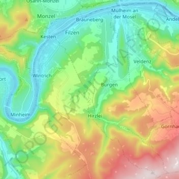
Name: Brauneberg topographic map, elevation, terrain.
Average elevation: 951 ft
Minimum elevation: 351 ft
Maximum elevation: 2,123 ft
Other topographic maps
Click on a map to view its topography, its elevation and its terrain.
Piesport
Germany > Rhineland-Palatinate > Landkreis Bernkastel-Wittlich
Piesport, Bernkastel-Kues, Landkreis Bernkastel-Wittlich, Rhineland-Palatinate, 54498, Germany
Average elevation: 807 ft
Zimmet
Germany > Rhineland-Palatinate > Landkreis Bernkastel-Wittlich > Piesport
Zimmet, Piesport, Bernkastel-Kues, Landkreis Bernkastel-Wittlich, Rhineland-Palatinate, 54498, Germany
Average elevation: 607 ft
Bernkastel
Germany > Rhineland-Palatinate > Landkreis Bernkastel-Wittlich > Bernkastel-Kues
Bernkastel, Bernkastel-Kues, Landkreis Bernkastel-Wittlich, Rhineland-Palatinate, Germany
Average elevation: 1,027 ft
Wittlich
Germany > Rhineland-Palatinate > Landkreis Bernkastel-Wittlich
Wittlich, Landkreis Bernkastel-Wittlich, Rhineland-Palatinate, 54516, Germany
Average elevation: 846 ft
Traben-Trarbach
Germany > Rhineland-Palatinate > Landkreis Bernkastel-Wittlich
Traben-Trarbach, Landkreis Bernkastel-Wittlich, Rhineland-Palatinate, 56841, Germany
Average elevation: 955 ft