
Dayr al Abyad topographic map
Interactive map
Click on the map to display elevation.
About this map
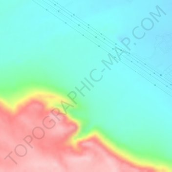
Name: Dayr al Abyad topographic map, elevation, terrain.
Location: Dayr al Abyad, New Valley Governorate, Egypt (26.54000 31.59000 26.56000 31.61000)
Average elevation: 449 ft
Minimum elevation: 230 ft
Maximum elevation: 876 ft
Other topographic maps
Click on a map to view its topography, its elevation and its terrain.
Rashida
Egypt > New Valley Governorate > Rashida
Rashida, New Valley Governorate, Egypt
Average elevation: 331 ft
El Dakhla Oasis
Egypt > New Valley Governorate > El Dakhla Oasis
El Dakhla Oasis, New Valley Governorate, Egypt
Average elevation: 673 ft
Al-Farafra
Egypt > New Valley Governorate > Al-Farafra
Al-Farafra, New Valley Governorate, Egypt
Average elevation: 240 ft
El Gilf El Kebir Plateau
Egypt > New Valley Governorate
El Gilf El Kebir Plateau, New Valley Governorate, Egypt
Average elevation: 3,402 ft
Al Izziyah
Egypt > New Valley Governorate > Al Izziyah
Al Izziyah, New Valley Governorate, Egypt
Average elevation: 223 ft
Aulad Salama
Egypt > New Valley Governorate > Aulad Salama
Aulad Salama, New Valley Governorate, Egypt
Average elevation: 236 ft
Hawd Dandarah
Egypt > New Valley Governorate > Al Ashraf al Bahriyah
Hawd Dandarah, Al Ashraf al Bahriyah, New Valley Governorate, Egypt
Average elevation: 243 ft