
Chikkamagaluru topographic map
Interactive map
Click on the map to display elevation.
About this map
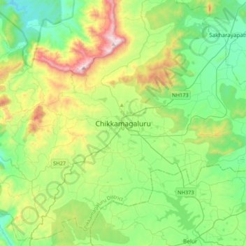
Name: Chikkamagaluru topographic map, elevation, terrain.
Average elevation: 3,451 ft
Minimum elevation: 2,339 ft
Maximum elevation: 6,178 ft
Chikmagalur is situated in the Malenadu region of Karnataka in the Deccan plateau in the foothills of the Western Ghats. It is situated at an elevation of 1,090 metres (3,580 ft) above mean sea level. The Yagachi River has its source near the town and flows in the south-easterly direction before uniting with the Hemavati river. Chikmagalur generally has a moderate to cool climate. The temperature of the city varies from 11-20 °C during winter to 25-32 °C during summer.
Other topographic maps
Click on a map to view its topography, its elevation and its terrain.
Mullayyanagiri
India > Karnataka > Chikkamagaluru taluku > Chikkamagaluru
Mullayyanagiri, Chikkamagaluru, Chikkamagaluru taluku, Chikkamagaluru district, Karnataka, 577101, India
Average elevation: 5,079 ft