
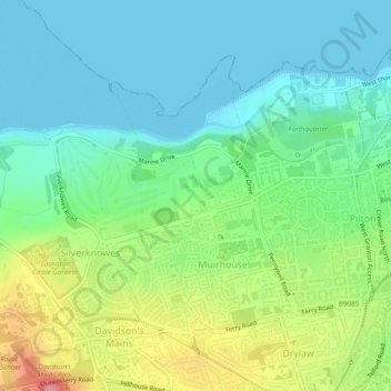
Muirhouse/Salvesen topographic map
Interactive map
Click on the map to display elevation.
About this map
Name: Muirhouse/Salvesen topographic map, elevation, terrain.
Average elevation: 95 ft
Minimum elevation: 0 ft
Maximum elevation: 308 ft
Other topographic maps
Click on a map to view its topography, its elevation and its terrain.
Arthur's Seat
United Kingdom > Scotland > Edinburgh
Arthur's Seat, Edinburgh, City of Edinburgh, Scotland, EH8 8HG, United Kingdom
Average elevation: 226 ft
Agassiz Rock
United Kingdom > Scotland > Edinburgh
Agassiz Rock, Howe Dean Path, Braid Hills, Edinburgh, City of Edinburgh, Scotland, EH16 6TR, United Kingdom
Average elevation: 358 ft
Old Town
United Kingdom > Scotland > Edinburgh
Old Town, Edinburgh, City of Edinburgh, Scotland, United Kingdom
Average elevation: 200 ft
Southside
United Kingdom > Scotland > Edinburgh
Southside, Edinburgh, City of Edinburgh, Scotland, United Kingdom
Average elevation: 253 ft