
Segusino topographic map
Interactive map
Click on the map to display elevation.
About this map
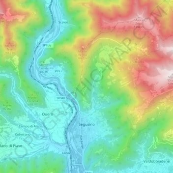
Name: Segusino topographic map, elevation, terrain.
Location: Segusino, Treviso, Veneto, Italy (45.89648 11.94374 45.96804 12.00759)
Average elevation: 1,929 ft
Minimum elevation: 548 ft
Maximum elevation: 4,905 ft
Other topographic maps
Click on a map to view its topography, its elevation and its terrain.
Monastier di Treviso
Monastier di Treviso, Treviso, Veneto, 31050, Italy
Average elevation: 23 ft
Valdobbiadene
Valdobbiadene, Treviso, Veneto, 31049, Italy
Average elevation: 1,798 ft
Vittorio Veneto
Vittorio Veneto, Treviso, Veneto, Italy
Average elevation: 1,722 ft
Lovigioni
Italy > Veneto > Treviso > San Vito di Altivole
Lovigioni, San Vito di Altivole, Altivole, Fonte, Treviso, Veneto, 31039, Italy
Average elevation: 269 ft
Castello di Godego
Castello di Godego, Fonte, Treviso, Veneto, Italy
Average elevation: 177 ft
Castelfranco Veneto
Castelfranco Veneto, Treviso, Veneto, 31033, Italy
Average elevation: 131 ft
Monte Grappa
Monte Grappa, Pieve del Grappa, Treviso, Veneto, Italy
Average elevation: 4,928 ft