
Zone 1 topographic map
Interactive map
Click on the map to display elevation.
About this map
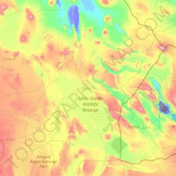
Name: Zone 1 topographic map, elevation, terrain.
Location: Zone 1, Afar Region, 7240, Ethiopia (10.78061 39.99344 13.08074 42.40418)
Average elevation: 1,614 ft
Minimum elevation: -505 ft
Maximum elevation: 6,312 ft
Other topographic maps
Click on a map to view its topography, its elevation and its terrain.
Danakil Depression
Danakil Depression, Zone 2, Afar Region, Ethiopia
Average elevation: -377 ft
Mille
Ethiopia > Afar Region > Lower Miele
Mille, Lower Miele, Zone 1, Afar Region, Ethiopia
Average elevation: 1,627 ft