
Πηνειός topographic map
Interactive map
Click on the map to display elevation.
About this map
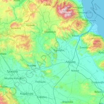
Name: Πηνειός topographic map, elevation, terrain.
Average elevation: 1,342 ft
Minimum elevation: -7 ft
Maximum elevation: 9,357 ft
Other topographic maps
Click on a map to view its topography, its elevation and its terrain.
Thessalien - Mittelgriechenland
Griechenland > Thessalien - Mittelgriechenland
Thessalien - Mittelgriechenland, Griechenland
Average elevation: 1,204 ft