
Keyser topographic map
Interactive map
Click on the map to display elevation.
About this map
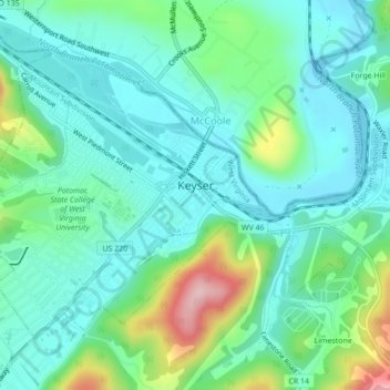
Name: Keyser topographic map, elevation, terrain.
Location: Keyser, Mineral County, West Virginia, 26726, United States (39.42777 -78.99890 39.45235 -78.95557)
Average elevation: 935 ft
Minimum elevation: 751 ft
Maximum elevation: 1,509 ft
Other topographic maps
Click on a map to view its topography, its elevation and its terrain.
Champwood
United States > West Virginia > Mineral County
Champwood, Mineral County, West Virginia, United States
Average elevation: 774 ft
Wiley Ford
United States > West Virginia > Mineral County
Wiley Ford, Mineral County, West Virginia, United States
Average elevation: 774 ft
Fort Ashby
United States > West Virginia > Mineral County > Fort Ashby
Fort Ashby, Mineral County, West Virginia, 26719, United States
Average elevation: 712 ft
Burlington
United States > West Virginia > Mineral County > Burlington
Burlington, Mineral County, West Virginia, 26710, United States
Average elevation: 856 ft