
Isla Teja topographic map
Interactive map
Click on the map to display elevation.
About this map
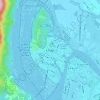
Name: Isla Teja topographic map, elevation, terrain.
Average elevation: 62 ft
Minimum elevation: -26 ft
Maximum elevation: 856 ft
Other topographic maps
Click on a map to view its topography, its elevation and its terrain.
Villa Las Américas
Chile > Los Ríos Region > Valdivia > Villa Las Américas
Villa Las Américas, Valdivia, Provincia de Valdivia, Los Ríos Region, 5100861, Chile
Average elevation: 171 ft