
Rend Lake topographic map
Interactive map
Click on the map to display elevation.
About this map
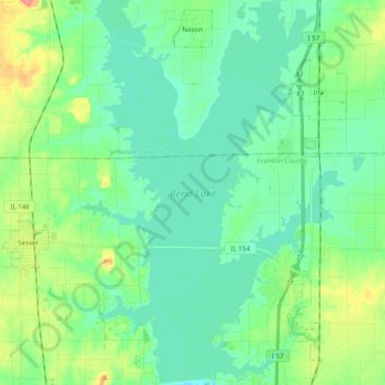
Name: Rend Lake topographic map, elevation, terrain.
Location: Rend Lake, Franklin County, Illinois, United States (38.03493 -89.01368 38.18750 -88.89034)
Average elevation: 433 ft
Minimum elevation: 381 ft
Maximum elevation: 584 ft
Other topographic maps
Click on a map to view its topography, its elevation and its terrain.
Christopher
United States > Illinois > Franklin County
Christopher, Franklin County, Illinois, 62822, United States
Average elevation: 427 ft
Benton
United States > Illinois > Franklin County
Benton, Franklin County, Illinois, 62812, United States
Average elevation: 433 ft
West Frankfort
United States > Illinois > Franklin County
West Frankfort, Franklin County, Illinois, 62896, United States
Average elevation: 400 ft
Thompsonville
United States > Illinois > Franklin County
Thompsonville, Franklin County, Illinois, United States
Average elevation: 482 ft
Royalton
United States > Illinois > Franklin County > Royalton
Royalton, Franklin County, Illinois, United States
Average elevation: 400 ft