
Pointe d'Otemma topographic map
Interactive map
Click on the map to display elevation.
About this map
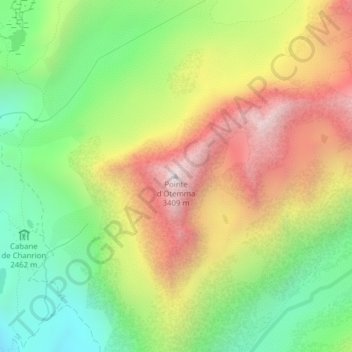
Name: Pointe d'Otemma topographic map, elevation, terrain.
Location: Pointe d'Otemma, Bagnes, Entremont, Vallese, 1934, Svizzera (45.94360 7.39765 45.94370 7.39775)
Average elevation: 9,032 ft
Minimum elevation: 7,320 ft
Maximum elevation: 11,122 ft
Other topographic maps
Click on a map to view its topography, its elevation and its terrain.
Grand Tavé
Grand Tavé, Bagnes, Entremont, Vallese, 1934, Svizzera
Average elevation: 8,783 ft
Le Parrain
Le Parrain, Bagnes, Entremont, Vallese, 1934, Svizzera
Average elevation: 9,534 ft
La Ruinette
La Ruinette, Bagnes, Entremont, Vallese, 1934, Svizzera
Average elevation: 10,873 ft
Tournelon Blanc
Tournelon Blanc, Bagnes, Entremont, Vallese, 1934, Svizzera
Average elevation: 10,043 ft
Le Pleureur
Le Pleureur, Bagnes, Entremont, Vallese, 1934, Svizzera
Average elevation: 9,797 ft
Glacier d'Otemma
Glacier d'Otemma, Bagnes, Entremont, Vallese, 1934, Svizzera
Average elevation: 10,259 ft
Aouille Tseuque
Aouille Tseuque, Bagnes, Entremont, Vallese, 1934, Svizzera
Average elevation: 9,875 ft
Combin de Corbassière
Combin de Corbassière, Bagnes, Entremont, Vallese, 1934, Svizzera
Average elevation: 10,528 ft