
Kronenberg topographic map
Interactive map
Click on the map to display elevation.
About this map
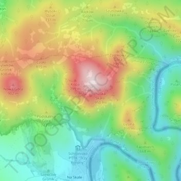
Name: Kronenberg topographic map, elevation, terrain.
Average elevation: 2,100 ft
Minimum elevation: 1,450 ft
Maximum elevation: 3,071 ft
Other topographic maps
Click on a map to view its topography, its elevation and its terrain.
Pieniny
Polen > Woiwodschaft Kleinpolen > Sromowce Niżne
Pieniny, Sromowce Niżne, gmina Czorsztyn, powiat nowotarski, Woiwodschaft Kleinpolen, 34-450, Polen
Average elevation: 2,073 ft