
Tragadero topographic map
Interactive map
Click on the map to display elevation.
About this map
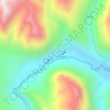
Name: Tragadero topographic map, elevation, terrain.
Location: Tragadero, Tanta, Yauyos, Lima, Perú (-12.07559 -75.95506 -12.05559 -75.93506)
Average elevation: 14,265 ft
Minimum elevation: 13,373 ft
Maximum elevation: 15,600 ft
Other topographic maps
Click on a map to view its topography, its elevation and its terrain.
Laguna Paucarcocha
Laguna Paucarcocha, Tanta, Provincia de Yauyos, Lima, Perú
Average elevation: 14,695 ft
Laguna Pumarauca
Laguna Pumarauca, LM-828, Tanta, Yauyos, Lima, Perú
Average elevation: 15,085 ft