
Bunnell topographic map
Interactive map
Click on the map to display elevation.
About this map
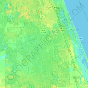
Name: Bunnell topographic map, elevation, terrain.
Location: Bunnell, Flagler County, Florida, 32110, United States (29.26230 -81.52268 29.58140 -81.17172)
Average elevation: 23 ft
Minimum elevation: -13 ft
Maximum elevation: 66 ft
Other topographic maps
Click on a map to view its topography, its elevation and its terrain.
Palm Coast
United States > Florida > Flagler County
Palm Coast, Flagler County, Florida, United States
Average elevation: 20 ft
Korona
United States > Florida > Flagler County
Korona, Flagler County, Florida, United States
Average elevation: 26 ft
Flagler Beach
United States > Florida > Flagler County
Flagler Beach, Flagler County, Florida, United States
Average elevation: 10 ft
Beverly Beach
United States > Florida > Flagler County
Beverly Beach, Flagler County, Florida, United States
Average elevation: 7 ft