
Bashkia Malësi e Madhe topographic map
Interactive map
Click on the map to display elevation.
About this map
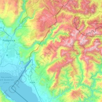
Name: Bashkia Malësi e Madhe topographic map, elevation, terrain.
Average elevation: 2,828 ft
Minimum elevation: -3 ft
Maximum elevation: 8,730 ft
Other topographic maps
Click on a map to view its topography, its elevation and its terrain.
Pukë
Albania > Northern Albania > Shkodër County > Pukë
Pukë, Bashkia Pukë, Shkodër County, Northern Albania, 4401, Albania
Average elevation: 2,618 ft
Velipojë
Albania > Northern Albania > Shkodër County
Velipojë, Shkodër Municipality, Shkodër County, Northern Albania, 4020, Albania
Average elevation: 75 ft
Shkoder
Albania > Northern Albania > Shkodër County
Shkoder, Shkodër Municipality, Shkodër County, Northern Albania, 4001-4007, Albania
Average elevation: 154 ft
Theth
Albania > Northern Albania > Shkodër County > Shalë
Theth, Shalë, Shkodër Municipality, Shkodër County, Northern Albania, 4009, Albania
Average elevation: 3,648 ft