
Spencer Bay topographic map
Interactive map
Click on the map to display elevation.
About this map
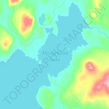
Name: Spencer Bay topographic map, elevation, terrain.
Location: Spencer Bay, Fire Rd 7C, Piscataquis County, Maine, USA (45.62504 -69.62450 45.72353 -69.54102)
Average elevation: 1,119 ft
Minimum elevation: 1,010 ft
Maximum elevation: 1,581 ft
Other topographic maps
Click on a map to view its topography, its elevation and its terrain.
Dog Island
Dog Island, Eastport, Washington County, Maine, 04631, USA
Average elevation: 85 ft
Tim Mountain
USA > Maine > Tim Pond Township
Tim Mountain, Tim Pond Township, Franklin County, Maine, USA
Average elevation: 2,602 ft
Tim Pond
USA > Maine > Tim Pond Township
Tim Pond, Green Gate Road, Tim Pond Township, Franklin County, Maine, USA
Average elevation: 2,083 ft
Phippsburg
USA > Maine > Phippsburg
Phippsburg, Sagadahoc County, Maine, 04562, USA
Average elevation: 75 ft
Cunningham Mountains
Cunningham Mountains, Penobscot County, Maine, USA
Average elevation: 860 ft
Wattons Mill
USA > Maine > Wattons Mill
Wattons Mill, Knox County, Maine, USA
Average elevation: 180 ft
Kidney Pond
Kidney Pond, Colt's Point Trail, Piscataquis County, Maine, USA
Average elevation: 1,112 ft