
Katowice topographic map
Interactive map
Click on the map to display elevation.
About this map
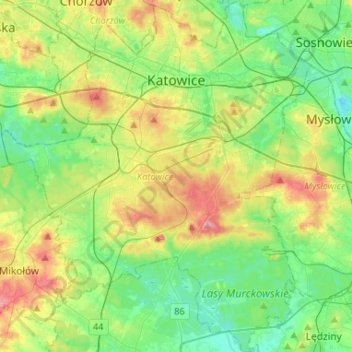
Name: Katowice topographic map, elevation, terrain.
Average elevation: 902 ft
Minimum elevation: 774 ft
Maximum elevation: 1,152 ft
Other topographic maps
Click on a map to view its topography, its elevation and its terrain.
Dąb
Poland > Silesian Voivodeship > Katowice
Dąb, Katowice, Górnośląsko-Zagłębiowska Metropolia, Silesian Voivodeship, Poland
Average elevation: 906 ft