
Lake Greeson topographic map
Interactive map
Click on the map to display elevation.
About this map
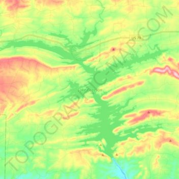
Name: Lake Greeson topographic map, elevation, terrain.
Location: Lake Greeson, Pike County, Arkansas, 71950, United States (34.14818 -93.83704 34.26039 -93.66063)
Average elevation: 640 ft
Minimum elevation: 400 ft
Maximum elevation: 997 ft
Other topographic maps
Click on a map to view its topography, its elevation and its terrain.
Crater of Diamonds State Park
United States > Arkansas > Pike County > Murfreesboro > Kimberley
Crater of Diamonds State Park, Kimberley, Murfreesboro, Pike County, Arkansas, 71958, United States
Average elevation: 348 ft
Little Missouri River
United States > Arkansas > Pike County
Little Missouri River, Pike County, Arkansas, 71958, United States
Average elevation: 522 ft
Antoine
United States > Arkansas > Pike County
Antoine, Pike County, Arkansas, United States
Average elevation: 295 ft
Glenwood
United States > Arkansas > Pike County > Glenwood
Glenwood, Pike County, Arkansas, United States
Average elevation: 633 ft
Delight
United States > Arkansas > Pike County > Delight
Delight, Pike County, Arkansas, 71940, United States
Average elevation: 390 ft
Murfreesboro
United States > Arkansas > Pike County
Murfreesboro, Pike County, Arkansas, 71958, United States
Average elevation: 374 ft