
Ilha do Pico topographic map
Interactive map
Click on the map to display elevation.
About this map
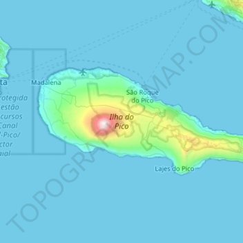
Name: Ilha do Pico topographic map, elevation, terrain.
Location: Ilha do Pico, Azores, Portugal (38.38207 -28.54190 38.56143 -28.02820)
Average elevation: 341 ft
Minimum elevation: 0 ft
Maximum elevation: 7,477 ft
Pico Island (Ilha do Pico, Portuguese pronunciation: [ˈiʎɐ du ˈpiku]) is an island in the Central Group of the Portuguese Azores. The landscape features an eponymous volcano, Ponta do Pico, which is the highest mountain in Portugal, the Azores, and the highest elevation of the Mid-Atlantic Ridge. In the tradition of the Portuguese poet, Raul Brandão, Pico is referred to as the Ilha Preta ("Black Island"), for its black volcanic soils, which nourish its UNESCO-designated vineyards that once allowed the development of the island's economy. Pico is the second largest and, geologically speaking, the most recently formed island of the Azores, being around 300,000 years old.[3]
Other topographic maps
Click on a map to view its topography, its elevation and its terrain.
Glória e Vera Cruz
Glória e Vera Cruz, Aveiro, Portugal
Average elevation: 13 ft
Vila Pequena
Portugal > Vila Real > Boticas > Dornelas
Vila Pequena, Dornelas, Boticas, Vila Real, Portugal
Average elevation: 2,556 ft
Ermida
Portugal > Viana do Castelo > Ponte da Barca
Ermida, Ponte da Barca, Viana do Castelo, 4980-213, Portugal
Average elevation: 1,739 ft
Ponte da Barca
Ponte da Barca, Viana do Castelo, Portugal
Average elevation: 1,188 ft
Troviscal
Portugal > Castelo Branco > Sertã
Troviscal, Sertã, Castelo Branco, Portugal
Average elevation: 1,785 ft
Reguengos de Monsaraz
Reguengos de Monsaraz, Évora, Portugal
Average elevation: 679 ft
Benquerença
Portugal > Castelo Branco > Penamacor
Benquerença, Penamacor, Castelo Branco, Portugal
Average elevation: 1,703 ft
Sistelo
Portugal > Viana do Castelo > Arcos de Valdevez
Sistelo, Arcos de Valdevez, Viana do Castelo, 4970-645, Portugal
Average elevation: 1,890 ft
Vale de Nogueira
Vale de Nogueira, Lousã e Vilarinho, Lousã, Coimbra, 3200-901, Portugal
Average elevation: 1,273 ft
Rates
Portugal > Porto > Póvoa de Varzim
Rates, Póvoa de Varzim, Porto, Portugal
Average elevation: 256 ft
Torre de Moncorvo
Torre de Moncorvo, Bragança, Portugal
Average elevation: 1,444 ft
Alqueidão da Serra
Portugal > Leiria > Porto de Mós
Alqueidão da Serra, Porto de Mós, Leiria, Portugal
Average elevation: 1,030 ft
Praia do Beliche
Praia do Beliche, Sagres, Vila do Bispo, Faro, Portugal
Average elevation: 95 ft
Pico Ruivo
Pico Ruivo, Santana, Madeira, 9030-311, Portugal
Average elevation: 4,593 ft
Quinta do Bispo
Portugal > Leiria > Pombal > Abiul
Quinta do Bispo, Abiul, Pombal, Leiria, Portugal
Average elevation: 715 ft
São Paio de Cima
Portugal > Braga > Esposende > Antas
São Paio de Cima, Antas, Esposende, Braga, 4740-438, Portugal
Average elevation: 371 ft
Foz do Tua
Portugal > Bragança > Carrazeda de Ansiães
Foz do Tua, Castanheiro do Norte e Ribalonga, Carrazeda de Ansiães, Bragança, Portugal
Average elevation: 915 ft
Santo Quintino
Portugal > Lisbon > Sobral de Monte Agraço
Santo Quintino, Sobral de Monte Agraço, Lisbon, Portugal
Average elevation: 804 ft
Santa Bárbara
Santa Bárbara, Ponta Delgada, Azores, Portugal
Average elevation: 892 ft