
Bulskamp topographic map
Interactive map
Click on the map to display elevation.
About this map
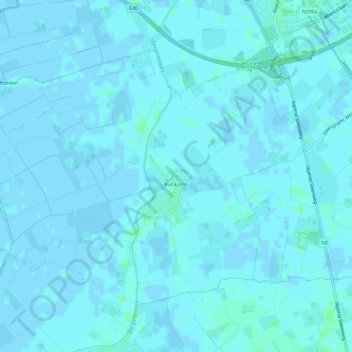
Name: Bulskamp topographic map, elevation, terrain.
Location: Bulskamp, Veurne, West Flanders, Flanders, 8630, Belgium (51.03124 2.61010 51.05794 2.66879)
Average elevation: 3 ft
Minimum elevation: -7 ft
Maximum elevation: 16 ft
Other topographic maps
Click on a map to view its topography, its elevation and its terrain.
Veurne
Belgium > West Flanders > Veurne > Veurne
Veurne, West Flanders, Flanders, Belgium
Average elevation: 7 ft
Beauvoorde
Belgium > West Flanders > Veurne > Veurne
Beauvoorde, Veurne, West Flanders, Flanders, 8630, Belgium
Average elevation: 16 ft