
Atlántida topographic map
Interactive map
Click on the map to display elevation.
About this map
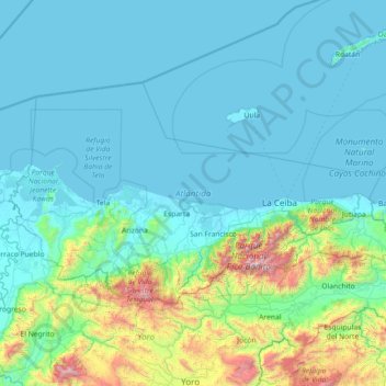
Name: Atlántida topographic map, elevation, terrain.
Location: Atlántida, Honduras (15.41924 -87.80227 16.21452 -86.36188)
Average elevation: 902 ft
Minimum elevation: -3 ft
Maximum elevation: 7,946 ft
Other topographic maps
Click on a map to view its topography, its elevation and its terrain.
Sambo Creek
Honduras > Atlántida > La Ceiba > Sambo Creek
Sambo Creek, La Ceiba, Atlántida, Honduras
Average elevation: 240 ft