
San Andrés Calpan topographic map
Interactive map
Click on the map to display elevation.
About this map
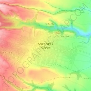
Name: San Andrés Calpan topographic map, elevation, terrain.
Location: San Andrés Calpan, Calpan, Puebla, 74190, México (19.08556 -98.48361 19.12556 -98.44361)
Average elevation: 7,969 ft
Minimum elevation: 7,556 ft
Maximum elevation: 8,327 ft
Other topographic maps
Click on a map to view its topography, its elevation and its terrain.
San Mateo Ozolco
San Mateo Ozolco, Calpan, Puebla, 74180, México
Average elevation: 8,622 ft