
Pichilemu topographic map
Interactive map
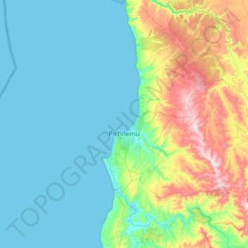
Click on the map to display elevation.
About this map
Name: Pichilemu topographic map, elevation, terrain.
Average elevation: 417 ft
Minimum elevation: 0 ft
Maximum elevation: 1,975 ft
Pichilemu is located 126 kilometres (78 mi) west of San Fernando, in the westernmost area of the O'Higgins Region, on the coast of the Pacific Ocean. It is within a three-hour drive of the Andes Mountains. It is near the Cordillera de la Costa (Coastal Mountain Range) which rises to 2,000 metres (6,562 ft) in elevation.
Other topographic maps
Click on a map to view its topography, its elevation and its terrain.
La Boca
Chile > O'Higgins Region > Provincia de Cardenal Caro
La Boca, Navidad, Provincia de Cardenal Caro, O'Higgins Region, Chile
Average elevation: 59 ft
Navidad
Chile > O'Higgins Region > Provincia de Cardenal Caro
Navidad, Provincia de Cardenal Caro, O'Higgins Region, Chile
Average elevation: 463 ft
Pupuya
Chile > O'Higgins Region > Provincia de Cardenal Caro > Navidad
Pupuya, Navidad, Provincia de Cardenal Caro, O'Higgins Region, Chile
Average elevation: 394 ft
Puertecillo
Chile > O'Higgins Region > Provincia de Cardenal Caro > Navidad > Puertecillo
Puertecillo, Navidad, Provincia de Cardenal Caro, O'Higgins Region, Chile
Average elevation: 358 ft