
Calingasta topographic map
Interactive map
Click on the map to display elevation.
About this map
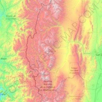
Name: Calingasta topographic map, elevation, terrain.
Location: Calingasta, San Juan, Argentina (-32.62663 -70.56968 -30.26862 -69.10017)
Average elevation: 7,851 ft
Minimum elevation: 243 ft
Maximum elevation: 21,598 ft
Calingasta has a rugged, hilly topography due to its location is at the foot of the Andes. The mountain Mercedario is the eighth-highest mountain of the Andes with an altitude of 6,720 metres (22,050 ft). It is located 100 kilometres (62 mi) north of Aconcagua. It is possible to highlight an area precordillerana lower height as the first with numerous mountain cave highlight the Sierra del Tontal. The soil is mainly desert with little vegetation cover except on the river banks in the valleys.
Other topographic maps
Click on a map to view its topography, its elevation and its terrain.
Villa San Andrés
Villa San Andrés, Capital, San Juan, Argentina
Average elevation: 2,169 ft
Ischigualasto Provincial Park
Ischigualasto Provincial Park, Valle Fértil, San Juan, Argentina
Average elevation: 4,127 ft
Quebrada Seca
Quebrada Seca, Iglesia, San Juan, Argentina
Average elevation: 14,219 ft
Hediondo (o Rincón del Diablo)
Hediondo (o Rincón del Diablo), Iglesia, San Juan, Argentina
Average elevation: 13,205 ft
Parkinson Hill
Parkinson Hill, Zonda, San Juan, 5478, Argentina
Average elevation: 4,383 ft
Quebrada Seca
Quebrada Seca, Calingasta, San Juan, Argentina
Average elevation: 10,190 ft
Cerro Mercedario
Cerro Mercedario, Calingasta, San Juan, Argentina
Average elevation: 20,105 ft