
Rioverde topographic map
Interactive map
Click on the map to display elevation.
About this map
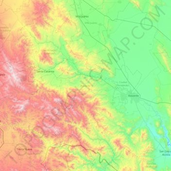
Name: Rioverde topographic map, elevation, terrain.
Location: Rioverde, San Luis Potosi, Mexico (21.55806 -100.40408 22.40216 -99.74135)
Average elevation: 4,770 ft
Minimum elevation: 2,648 ft
Maximum elevation: 8,868 ft
Other topographic maps
Click on a map to view its topography, its elevation and its terrain.
Rioverde
Mexico > San Luis Potosi > Rioverde
Rioverde, San Luis Potosi, 79610, Mexico
Average elevation: 3,261 ft