
Schladming topographic map
Interactive map
Click on the map to display elevation.
About this map
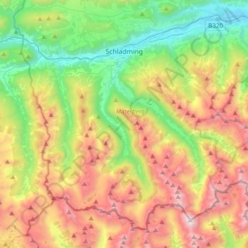
Name: Schladming topographic map, elevation, terrain.
Average elevation: 5,092 ft
Minimum elevation: 2,274 ft
Maximum elevation: 9,285 ft
Other topographic maps
Click on a map to view its topography, its elevation and its terrain.
Sankt Gallen
Austria > Styria > Bezirk Liezen
Sankt Gallen, Bezirk Liezen, Styria, 8933, Austria
Average elevation: 3,031 ft
Schafberg
Austria > Styria > Bezirk Liezen > Liezen
Schafberg, Liezen, Bezirk Liezen, Styria, 8940, Austria
Average elevation: 5,220 ft
Ramsau am Dachstein
Austria > Styria > Bezirk Liezen
Ramsau am Dachstein, Politische Expositur Gröbming, Bezirk Liezen, Styria, 8972, Austria
Average elevation: 5,007 ft
Gröbming
Austria > Styria > Bezirk Liezen > Gröbming
Gröbming, Politische Expositur Gröbming, Bezirk Liezen, Styria, 8962, Austria
Average elevation: 3,740 ft
Bad Aussee
Austria > Styria > Bezirk Liezen
Bad Aussee, Bezirk Liezen, Styria, 8990, Austria
Average elevation: 3,875 ft