
Rosenheim topographic map
Interactive map
Click on the map to display elevation.
About this map
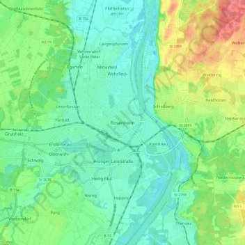
Name: Rosenheim topographic map, elevation, terrain.
Location: Rosenheim, Bayern, Oberbayern, Bayern, 83022, Deutschland (47.81393 12.08726 47.89393 12.16726)
Average elevation: 1,522 ft
Minimum elevation: 1,427 ft
Maximum elevation: 1,742 ft
Other topographic maps
Click on a map to view its topography, its elevation and its terrain.
83024
Deutschland > Bayern > Rosenheim
83024, Rosenheim, Bayern, Deutschland
Average elevation: 1,483 ft
Unterfürstätt
Deutschland > Bayern > Rosenheim > Unterfürstätt
Unterfürstätt, Rosenheim, Oberbayern, Bayern, 83024, Deutschland
Average elevation: 1,496 ft