
Ennepetal topographic map
Interactive map
Click on the map to display elevation.
About this map
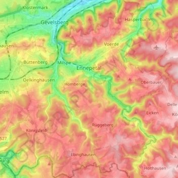
Name: Ennepetal topographic map, elevation, terrain.
Average elevation: 968 ft
Minimum elevation: 479 ft
Maximum elevation: 1,335 ft
Other topographic maps
Click on a map to view its topography, its elevation and its terrain.
Pöting
Germany > North Rhine-Westphalia > Ennepe-Ruhr-Kreis > Sprockhövel
Pöting, Sprockhövel, Ennepe-Ruhr-Kreis, North Rhine-Westphalia, 45549, Germany
Average elevation: 728 ft
Breckerfeld
Germany > North Rhine-Westphalia > Ennepe-Ruhr-Kreis > Breckerfeld > Breckerfeld
Breckerfeld, Ennepe-Ruhr-Kreis, North Rhine-Westphalia, 58339, Germany
Average elevation: 1,122 ft
Gevelsberg
Germany > North Rhine-Westphalia > Ennepe-Ruhr-Kreis
Gevelsberg, Ennepe-Ruhr-Kreis, North Rhine-Westphalia, 58285, Germany
Average elevation: 748 ft