
Hilchenbach topographic map
Interactive map
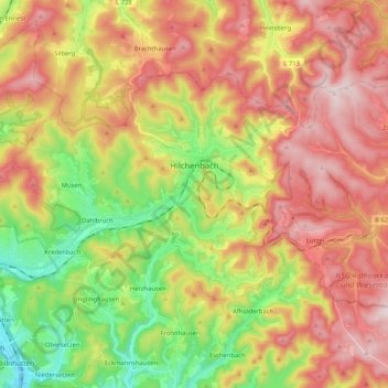
Click on the map to display elevation.
About this map
Name: Hilchenbach topographic map, elevation, terrain.
Average elevation: 1,549 ft
Minimum elevation: 840 ft
Maximum elevation: 2,244 ft
The town's largest flowing body of water is the Ferndorfbach, a tributary to the river Sieg. The municipal area's average elevation is 427 metres (1,401 ft) above sea level, with its highest elevation being at 678 metres (2,224 ft) at the Riemen, a peak in the Rothaargebirge.
Other topographic maps
Click on a map to view its topography, its elevation and its terrain.
Hilchenbach
Germany > North Rhine-Westphalia > Kreis Siegen-Wittgenstein > Hilchenbach > Hilchenbach
Hilchenbach, Kreis Siegen-Wittgenstein, North Rhine-Westphalia, 57271, Germany
Average elevation: 1,526 ft
Siegen
Germany > North Rhine-Westphalia > Kreis Siegen-Wittgenstein > Siegen
Siegen, Kreis Siegen-Wittgenstein, North Rhine-Westphalia, 57072, Germany
Average elevation: 1,316 ft