
Nördlingen topographic map
Interactive map
Click on the map to display elevation.
About this map
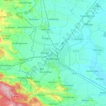
Name: Nördlingen topographic map, elevation, terrain.
Location: Nördlingen, Landkreis Donau-Ries, Bavaria, Germany (48.79459 10.42648 48.92256 10.59398)
Average elevation: 1,486 ft
Minimum elevation: 1,339 ft
Maximum elevation: 2,126 ft
Other topographic maps
Click on a map to view its topography, its elevation and its terrain.
Rain
Germany > Bavaria > Landkreis Donau-Ries
Rain, Rain (Schwaben), Landkreis Donau-Ries, Bavaria, 86641, Germany
Average elevation: 1,358 ft
Deiningen
Germany > Bavaria > Landkreis Donau-Ries
Deiningen, Ries, Landkreis Donau-Ries, Bavaria, 86738, Germany
Average elevation: 1,375 ft
Wechingen
Germany > Bavaria > Landkreis Donau-Ries
Wechingen, Ries, Landkreis Donau-Ries, Bavaria, 86759, Germany
Average elevation: 1,368 ft