
Bejaia topographic map
Interactive map
Click on the map to display elevation.
About this map
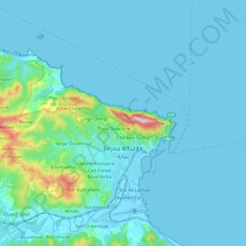
Name: Bejaia topographic map, elevation, terrain.
Location: Bejaia, Bejaia District, Bejaia, 06000, Algeria (36.70562 4.90867 36.83365 5.10747)
Average elevation: 197 ft
Minimum elevation: -7 ft
Maximum elevation: 2,113 ft
Other topographic maps
Click on a map to view its topography, its elevation and its terrain.
Oued Ghir
Algeria > Bejaia > Bejaia District > Oued Ghir
Oued Ghir, Bejaia District, Bejaia, 06017, Algeria
Average elevation: 492 ft