
St. John's topographic map
Interactive map
Click on the map to display elevation.
About this map
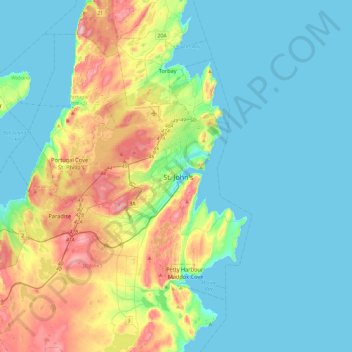
Name: St. John's topographic map, elevation, terrain.
Average elevation: 217 ft
Minimum elevation: -3 ft
Maximum elevation: 892 ft
Other topographic maps
Click on a map to view its topography, its elevation and its terrain.
Airport Road
Canada > Newfoundland and Labrador > St. John's
Airport Road, St. John's, Newfoundland, Newfoundland and Labrador, A1A 4Y3, Canada
Average elevation: 476 ft
Blackhead
Canada > Newfoundland and Labrador > St. John's > Blackhead
Blackhead, St. John's, Newfoundland and Labrador, Canada
Average elevation: 157 ft