
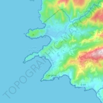
Cargèse topographic map
Interactive map
Click on the map to display elevation.
About this map
Name: Cargèse topographic map, elevation, terrain.
Average elevation: 272 ft
Minimum elevation: -7 ft
Maximum elevation: 2,283 ft
Other topographic maps
Click on a map to view its topography, its elevation and its terrain.
Marchese
France > Corsica > South Corsica > Cargèse
Marchese, Cargèse, Ajaccio, South Corsica, Corsica, Metropolitan France, 20130, France
Average elevation: 161 ft