
La Manga topographic map
Interactive map
Click on the map to display elevation.
About this map
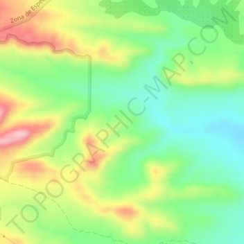
Name: La Manga topographic map, elevation, terrain.
Location: La Manga, Moratalla, Noroeste, Región de Murcia, España (38.27564 -1.81879 38.29564 -1.79879)
Average elevation: 1,565 ft
Minimum elevation: 1,296 ft
Maximum elevation: 1,955 ft
Other topographic maps
Click on a map to view its topography, its elevation and its terrain.
Benízar
España > Región de Murcia > Región de Murcia > Moratalla > Benízar
Benízar, Moratalla, Noroeste, Región de Murcia, España
Average elevation: 3,228 ft