
Santurtzi topographic map
Interactive map
Click on the map to display elevation.
About this map
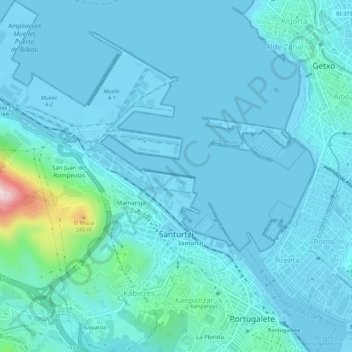
Name: Santurtzi topographic map, elevation, terrain.
Average elevation: 112 ft
Minimum elevation: -10 ft
Maximum elevation: 1,050 ft
Santurce has a very rough orography although excluding Mount Serantes (452m) - one of its most symbolic topographic elements, it is not at high altitude, the significant heights being spurs of the Serantes: The Mallet (245m) and the Fortified heights (123 and 106m). Its relief is within the north flank of the anticline of Biscay. It is a relief of a structural type corresponding to a series of materials of the Cretaceous period (limestone) throughout Punta Lucero-Serantes smoothly inclined towards the Estuary of Bilbao.