
Peñafiel topographic map
Interactive map
Click on the map to display elevation.
About this map
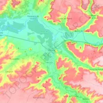
Name: Peñafiel topographic map, elevation, terrain.
Location: Peñafiel, Valladolid, Castile and León, 47300, Spain (41.54976 -4.22444 41.64233 -4.04123)
Average elevation: 2,703 ft
Minimum elevation: 2,395 ft
Maximum elevation: 3,028 ft
Other topographic maps
Click on a map to view its topography, its elevation and its terrain.
Peñafiel
Spain > Castile and León > Peñafiel > Peñafiel
Peñafiel, Valladolid, Castile and León, 47300, Spain
Average elevation: 2,533 ft