
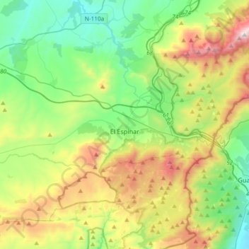
El Espinar topographic map
Interactive map
Click on the map to display elevation.
About this map
Name: El Espinar topographic map, elevation, terrain.
Location: El Espinar, Segovia, Castile and León, Spain (40.63680 -4.36471 40.80998 -4.07006)
Average elevation: 4,344 ft
Minimum elevation: 2,963 ft
Maximum elevation: 7,185 ft
The documented history of El Espinar dates from the 11th century, even though the area has been inhabited since the Iron Age. In fact, in September 2016 was found the settlement of Canto Los Hierros in a nearby mountain located south of town, just at 1,700 metres above sea level. The settlement, dated back to the Iron Age, covered about seventy hectares and included about one hundred of houses, few traces of walls and quite a lot of iron items. This kind of ancient settlement at such a high altitude is considered unique within Europe. In 1293 the town received the foundation document called as Carta Puebla, which makes the town independent from the city of Segovia. The Carta Puebla was renewed later in 1317 and in 1368, which allowed the municipality to increase its territory. During the 18th century, both the economy and the population boosted because of the sheep wool production and for the replacement of the farthest mountain pass of La Fuenfría by the nearest one of Los Leones as the safest, main mountain pass to travel between Madrid and the northwestern quadrant of the Iberian Peninsula. In 1888, the railway between Madrid and Segovia was built, so the town experienced a boost as less time was needed to travel from El Espinar to both Madrid and Segovia. In the early 20th century, the town became more and more famous for people from Madrid as a place to spend summer holidays whilst keeping away from the hotter Madrid's summers. During the early 21st century, the town increased its population as more and more people from Madrid moved to the area to live permanently as commuters.
Other topographic maps
Click on a map to view its topography, its elevation and its terrain.
Santa Marta de Tormes
Santa Marta de Tormes, Salamanca, Castile and León, Spain
Average elevation: 2,621 ft
Alba de Cerrato
Alba de Cerrato, Palencia, Castile and León, 34219, Spain
Average elevation: 2,713 ft
La Nogada
Spain > Castile and León > Cardeñuela Riopico
La Nogada, Cardeñuela Riopico, Burgos, Castile and León, 09198, Spain
Average elevation: 3,294 ft
Villaverde de Medina
Villaverde de Medina, Valladolid, Castile and León, 47465, Spain
Average elevation: 2,441 ft
Tordesillas
Tordesillas, Valladolid, Castile and León, Spain
Average elevation: 2,405 ft
Wamba
Wamba, Valladolid, Castile and León, 47190, Spain
Average elevation: 2,730 ft
Langa de Duero
Langa de Duero, Soria, Castile and León, Spain
Average elevation: 3,087 ft
Chollas
Spain > Castile and León > Rosinos de la Requejada
Chollas, Rosinos de la Requejada, Zamora, Castile and León, Spain
Average elevation: 4,265 ft
Camino de Santiago
Spain > Castile and León > Zazuar
Camino de Santiago, Zazuar, Ribera del Duero, Burgos, Castile and León, 09490, Spain
Average elevation: 2,782 ft
Palacios del Sil
Palacios del Sil, León, Castile and León, 24495, Spain
Average elevation: 4,393 ft
Real Sitio de San Ildefonso
Real Sitio de San Ildefonso, Segovia, Castile and León, Spain
Average elevation: 5,125 ft
Monforte de la Sierra
Monforte de la Sierra, Salamanca, Castile and León, 37618, Spain
Average elevation: 2,569 ft
Valverde de la Virgen
Valverde de la Virgen, León, Castile and León, 24198, Spain
Average elevation: 2,999 ft
Ayuela
Ayuela, Palencia, Castile and León, 34473, Spain
Average elevation: 3,301 ft
San Cebrián de Mazote
San Cebrián de Mazote, Valladolid, Castile and León, 47129, Spain
Average elevation: 2,664 ft
Navarredonda de Gredos
Navarredonda de Gredos, Ávila, Castile and León, Spain
Average elevation: 5,315 ft
Ólvega
Ólvega, Soria, Castile and León, 42110, Spain
Average elevation: 3,707 ft
Sotoserrano
Sotoserrano, Salamanca, Castile and León, 37657, Spain
Average elevation: 1,995 ft
Mogote
Spain > Castile and León > Mijares
Mogote, Mijares, Ávila, Castile and León, 05461, Spain
Average elevation: 3,540 ft
Mariposa
Spain > Castile and León > Becilla de Valderaduey
Mariposa, Becilla de Valderaduey, Valladolid, Castile and León, 47670, Spain
Average elevation: 2,470 ft
Los Gatos
Spain > Castile and León > Villafrades de Campos
Los Gatos, Villafrades de Campos, Valladolid, Castile and León, 47696, Spain
Average elevation: 2,516 ft
Ponferrada
Spain > Castile and León > El Bierzo
Ponferrada, El Bierzo, León, Castile and León, Spain
Average elevation: 2,897 ft
Poblado del Salto de Aldeadávila
Spain > Castile and León > Aldeadávila de la Ribera
Poblado del Salto de Aldeadávila, Aldeadávila de la Ribera, Salamanca, Castile and León, 37254, Spain
Average elevation: 1,755 ft
Oncina de la Valdoncina
Spain > Castile and León > Valverde de la Virgen
Oncina de la Valdoncina, Valverde de la Virgen, León, Castile and León, 24198, Spain
Average elevation: 2,907 ft
Cruz del Molino
Spain > Castile and León > Valle de Santibáñez
Cruz del Molino, Valle de Santibáñez, Burgos, Castile and León, Spain
Average elevation: 3,209 ft
Los Ventorros
Spain > Castile and León > Terradillos
Los Ventorros, Terradillos, Salamanca, Castile and León, 37800, Spain
Average elevation: 2,772 ft
Chozas de Abajo
Chozas de Abajo, León, Castile and León, 24392, Spain
Average elevation: 2,818 ft
Mirabuena
Spain > Castile and León > Palencia
Mirabuena, Palencia, Castile and León, 34005, Spain
Average elevation: 2,579 ft
Cerro de la Encinilla
Spain > Castile and León > El Tiemblo
Cerro de la Encinilla, El Tiemblo, Ávila, Castile and León, Spain
Average elevation: 4,373 ft
Espinosa de los Monteros
Espinosa de los Monteros, Burgos, Castile and León, Spain
Average elevation: 3,015 ft
Picos de Europa National Park
Spain > Castile and León > Liébana
Picos de Europa National Park, Liébana, León, Castile and León, Spain
Average elevation: 3,579 ft
Palacios de la Sierra
Palacios de la Sierra, Burgos, Castile and León, 09680, Spain
Average elevation: 3,822 ft
Aranda de Duero
Spain > Castile and León > Aranda de Duero
Aranda de Duero, Ribera del Duero, Burgos, Castile and León, 09400, Spain
Average elevation: 2,776 ft
El Durazno
Spain > Castile and León > Candeleda
El Durazno, Candeleda, Ávila, Castile and León, Spain
Average elevation: 6,033 ft
Presilla
Spain > Castile and León > Cayuela
Presilla, Cayuela, Burgos, Castile and León, 09514, Spain
Average elevation: 2,789 ft
Las Anchas
Spain > Castile and León > Arévalo de la Sierra
Las Anchas, Arévalo de la Sierra, Soria, Castile and León, 42161, Spain
Average elevation: 4,085 ft
Valbuena de Duero
Spain > Castile and León > Valbuena de Duero
Valbuena de Duero, Valladolid, Castile and León, Spain
Average elevation: 2,707 ft
Aguilar de Campoo
Spain > Castile and León > Aguilar de Campoo
Aguilar de Campoo, Palencia, Castile and León, 34800, Spain
Average elevation: 3,002 ft
A Corona
Spain > Castile and León > El Bierzo > Candín
A Corona, Candín, El Bierzo, León, Castile and León, 24433, Spain
Average elevation: 3,232 ft
Guimares
Spain > Castile and León > Gallegos del Río
Guimares, Gallegos del Río, Zamora, Castile and León, Spain
Average elevation: 2,441 ft
El Arizón
Spain > Castile and León > Villar de Gallimazo
El Arizón, Villar de Gallimazo, Salamanca, Castile and León, 37320, Spain
Average elevation: 2,743 ft
Oencia
Spain > Castile and León > Oencia
Oencia, El Bierzo, León, Castile and León, Spain
Average elevation: 3,169 ft
Campala
Spain > Castile and León > Berrocal de Salvatierra
Campala, Berrocal de Salvatierra, Salamanca, Castile and León, Spain
Average elevation: 2,982 ft
Peñafiel
Spain > Castile and León > Peñafiel > Peñafiel
Peñafiel, Valladolid, Castile and León, 47300, Spain
Average elevation: 2,533 ft
Glorieta
Spain > Castile and León > Salamanca
Glorieta, Salamanca, Castile and León, Spain
Average elevation: 2,703 ft