
United Kingdom topographic map
Interactive map
Click on the map to display elevation.
About this map
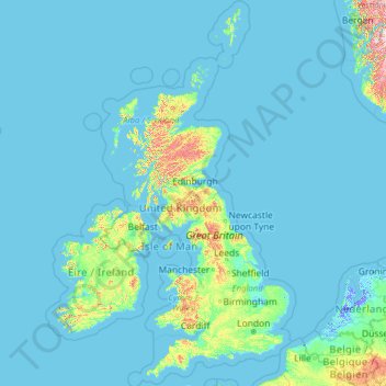
Name: United Kingdom topographic map, elevation, terrain.
Location: United Kingdom (49.67400 -14.01552 61.06100 2.09191)
Average elevation: 138 ft
Minimum elevation: -20 ft
Maximum elevation: 5,305 ft
Scotland accounts for just under one-third (32 per cent) of the total area of the UK, covering 78,772 square kilometres (30,410 sq mi). This includes nearly 800 islands, predominantly west and north of the mainland; notably the Hebrides, Orkney Islands and Shetland Islands. Scotland is the most mountainous country in the UK and its topography is distinguished by the Highland Boundary Fault – a geological rock fracture – which traverses Scotland from Arran in the west to Stonehaven in the east. The fault separates two distinctively different regions; namely the Highlands to the north and west and the Lowlands to the south and east. The more rugged Highland region contains the majority of Scotland's mountainous land, including Ben Nevis which at 1,345 metres (4,413 ft) is the highest point in the British Isles. Lowland areas – especially the narrow waist of land between the Firth of Clyde and the Firth of Forth known as the Central Belt – are flatter and home to most of the population including Glasgow, Scotland's largest city, and Edinburgh, its capital and political centre, although upland and mountainous terrain lies within the Southern Uplands.
Other topographic maps
Click on a map to view its topography, its elevation and its terrain.
United States
United States
Average elevation: 1,014 ft
Seattle
United States > Washington > King County
Seattle, King County, Washington, United States
Average elevation: 131 ft
Dallas
United States > Texas > Dallas County
Dallas, Dallas County, Texas, United States
Average elevation: 525 ft
Houston
United States > Texas > Harris County
Houston, Harris County, Texas, United States
Average elevation: 82 ft
Miami
United States > Florida > Miami-Dade County
Miami, Miami-Dade County, Florida, United States
Average elevation: 16 ft
San Francisco
San Francisco, California, United States
Average elevation: 207 ft
Las Vegas
United States > Nevada > Clark County
Las Vegas, Clark County, Nevada, United States
Average elevation: 2,480 ft
Austin
United States > Texas > Travis County
Austin, Travis County, Texas, United States
Average elevation: 709 ft
Phoenix
United States > Arizona > Maricopa County
Phoenix, Maricopa County, Arizona, United States
Average elevation: 1,578 ft
San Diego
United States > California > San Diego County
San Diego, San Diego County, California, United States
Average elevation: 410 ft
Chicago
United States > Illinois > Cook County
Chicago, Cook County, Illinois, United States
Average elevation: 597 ft
Salt Lake City
United States > Utah > Salt Lake County
Salt Lake City, Salt Lake County, Utah, United States
Average elevation: 5,223 ft
Philadelphia
United States > Pennsylvania > Philadelphia County
Philadelphia, Pennsylvania, United States
Average elevation: 144 ft
Pittsburgh
United States > Pennsylvania > Allegheny County
Pittsburgh, Allegheny County, Pennsylvania, United States
Average elevation: 994 ft
Portland
United States > Oregon > Multnomah County
Portland, Multnomah County, Oregon, United States
Average elevation: 253 ft
Saint Petersburg
United States > Florida > Pinellas County
Saint Petersburg, Pinellas County, Florida, United States
Average elevation: 13 ft
Boston
United States > Massachusetts > Suffolk County
Boston, Suffolk County, Massachusetts, United States
Average elevation: 82 ft
Louisville
United States > Kentucky > Jefferson County
Louisville, Jefferson County, Kentucky, United States
Average elevation: 617 ft
Colorado Springs
United States > Colorado > El Paso County
Colorado Springs, El Paso County, Colorado, United States
Average elevation: 7,388 ft
San Antonio
United States > Texas > Bexar County
San Antonio, Bexar County, Texas, United States
Average elevation: 810 ft
Reno
United States > Nevada > Washoe County
Reno, Washoe County, Nevada, United States
Average elevation: 5,413 ft
Oʻahu
United States > Hawaii > Honolulu County
Oʻahu, Honolulu County, Hawaii, United States
Average elevation: 259 ft
Eugene
United States > Oregon > Lane County
Eugene, Lane County, Oregon, United States
Average elevation: 535 ft
Tallahassee
United States > Florida > Leon County
Tallahassee, Leon County, Florida, United States
Average elevation: 118 ft
Omaha
United States > Nebraska > Douglas County
Omaha, Douglas County, Nebraska, United States
Average elevation: 1,109 ft
Denver
United States > Colorado > Denver County > Denver
Denver, Denver County, Colorado, United States
Average elevation: 5,525 ft
Cincinnati
United States > Ohio > Hamilton County
Cincinnati, Hamilton County, Ohio, United States
Average elevation: 728 ft
City of London
United Kingdom > England > City of London > City of London
City of London, England, EC2V 5AE, United Kingdom
Average elevation: 138 ft
Charlotte
United States > North Carolina > Mecklenburg County
Charlotte, Mecklenburg County, North Carolina, United States
Average elevation: 679 ft
Asheville
United States > North Carolina > Buncombe County
Asheville, Buncombe County, North Carolina, United States
Average elevation: 2,385 ft
Columbus
United States > Ohio > Franklin County
Columbus, Franklin County, Ohio, United States
Average elevation: 856 ft
Minneapolis
United States > Minnesota > Hennepin County
Minneapolis, Hennepin County, Minnesota, United States
Average elevation: 886 ft