
Johannesburg topographic map
Interactive map
Click on the map to display elevation.
About this map
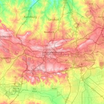
Name: Johannesburg topographic map, elevation, terrain.
Average elevation: 5,299 ft
Minimum elevation: 4,626 ft
Maximum elevation: 5,935 ft
Johannesburg is located in the eastern plateau area of South Africa known as the Highveld, at an elevation of 1,753 metres (5,751 ft). The former Central Business District is located on the southern side of the prominent ridge called the Witwatersrand (English: White Water's Ridge) and the terrain falls to the north and south. By and large the Witwatersrand marks the watershed between the Limpopo and Vaal rivers as the northern part of the city is drained by the Jukskei River while the southern part of the city, including most of the Central Business District, is drained by the Klip River. The north and west of the city has undulating hills while the eastern parts are flatter.
Other topographic maps
Click on a map to view its topography, its elevation and its terrain.
Midrand
South Africa > Gauteng > City of Johannesburg Metropolitan Municipality
Midrand, City of Johannesburg Metropolitan Municipality, Gauteng, 1685, South Africa
Average elevation: 5,059 ft
Sandton
South Africa > Gauteng > City of Johannesburg Metropolitan Municipality
Sandton, City of Johannesburg Metropolitan Municipality, Gauteng, 2031, South Africa
Average elevation: 5,194 ft
Soweto
South Africa > Gauteng > City of Johannesburg Metropolitan Municipality
Soweto, City of Johannesburg Metropolitan Municipality, Gauteng, 1852, South Africa
Average elevation: 5,374 ft
Darrenwood Park
South Africa > Gauteng > City of Johannesburg Metropolitan Municipality > Johannesburg
Darrenwood Park, Johannesburg Ward 98, Johannesburg, City of Johannesburg Metropolitan Municipality, Gauteng, 2001, South Africa
Average elevation: 5,243 ft
City of Johannesburg Metropolitan Municipality
South Africa > Gauteng > City of Johannesburg Metropolitan Municipality
City of Johannesburg Metropolitan Municipality, Gauteng, 2904, South Africa
Average elevation: 5,299 ft
Chartwell Gardens
South Africa > Gauteng > City of Johannesburg Metropolitan Municipality > Johannesburg
Chartwell Gardens, Killarney, Johannesburg Ward 73, Johannesburg, City of Johannesburg Metropolitan Municipality, Gauteng, 2001, South Africa
Average elevation: 5,587 ft
Diepsloot
South Africa > Gauteng > City of Johannesburg Metropolitan Municipality > Diepsloot
Diepsloot, City of Johannesburg Metropolitan Municipality, Gauteng, 2189, South Africa
Average elevation: 4,616 ft
Roodepoort
South Africa > Gauteng > City of Johannesburg Metropolitan Municipality > Roodepoort
Roodepoort, City of Johannesburg Metropolitan Municipality, Gauteng, 1850, South Africa
Average elevation: 5,289 ft
Randburg
South Africa > Gauteng > City of Johannesburg Metropolitan Municipality
Randburg, City of Johannesburg Metropolitan Municipality, Gauteng, 2194, South Africa
Average elevation: 5,148 ft
Rosebank
South Africa > Gauteng > City of Johannesburg Metropolitan Municipality
Rosebank, City of Johannesburg Metropolitan Municipality, Gauteng, 2132, South Africa
Average elevation: 5,374 ft
Roodepoort
South Africa > Gauteng > City of Johannesburg Metropolitan Municipality
Roodepoort, City of Johannesburg Metropolitan Municipality, Gauteng, South Africa
Average elevation: 5,226 ft