
Lège-Cap-Ferret topographic map
Interactive map
Click on the map to display elevation.
About this map
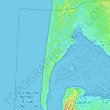
Name: Lège-Cap-Ferret topographic map, elevation, terrain.
Average elevation: 13 ft
Minimum elevation: -7 ft
Maximum elevation: 207 ft
Other topographic maps
Click on a map to view its topography, its elevation and its terrain.
Lège-Cap-Ferret
France > Nouvelle-Aquitaine > Gironde > Lège-Cap-Ferret
Lège-Cap-Ferret, Arcachon, Gironde, Nouvelle-Aquitaine, Metropolitan France, 33740, France
Average elevation: 26 ft