
Houffalize topographic map
Interactive map
Click on the map to display elevation.
About this map
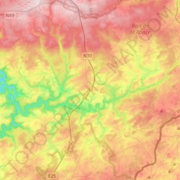
Name: Houffalize topographic map, elevation, terrain.
Location: Houffalize, Bastogne, Luxembourg, Wallonia, Belgium (50.06159 5.65189 50.23613 5.89551)
Average elevation: 1,519 ft
Minimum elevation: 833 ft
Maximum elevation: 2,106 ft
Other topographic maps
Click on a map to view its topography, its elevation and its terrain.
Ourthe
Belgium > Luxembourg > Bastogne
Ourthe, Gouvy, Bastogne, Luxembourg, Wallonia, 6672, Belgium
Average elevation: 1,611 ft
Ollomont
Belgium > Luxembourg > Bastogne > Houffalize
Ollomont, Nadrin, Houffalize, Bastogne, Luxembourg, Wallonia, 6982, Belgium
Average elevation: 1,234 ft
Wibrin
Belgium > Luxembourg > Bastogne
Wibrin, Houffalize, Bastogne, Luxembourg, Wallonia, Belgium
Average elevation: 1,391 ft
Bastogne
Belgium > Luxembourg > Bastogne
Bastogne, Luxembourg, Wallonia, 6600, Belgium
Average elevation: 1,526 ft
Regné
Belgium > Luxembourg > Bastogne
Regné, Vielsalm, Bastogne, Luxembourg, Wallonia, 4990, Belgium
Average elevation: 1,759 ft
Rogery
Belgium > Luxembourg > Bastogne > Rogery
Rogery, Gouvy, Bastogne, Luxembourg, Wallonia, 6671, Belgium
Average elevation: 1,591 ft
Gouvy
Belgium > Luxembourg > Bastogne > Gouvy
Gouvy, Bastogne, Luxembourg, Wallonia, Belgium
Average elevation: 1,539 ft
Vielsalm
Belgium > Luxembourg > Bastogne
Vielsalm, Bastogne, Luxembourg, Wallonia, Belgium
Average elevation: 1,549 ft
Gouvy
Belgium > Luxembourg > Bastogne
Gouvy, Bastogne, Luxembourg, Wallonia, Belgium
Average elevation: 1,585 ft
Baclain
Belgium > Luxembourg > Bastogne
Baclain, Gouvy, Bastogne, Luxembourg, Wallonia, 6673, Belgium
Average elevation: 1,539 ft