
Victoria Falls topographic map
Interactive map
Click on the map to display elevation.
About this map
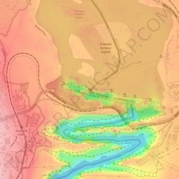
Name: Victoria Falls topographic map, elevation, terrain.
Location: Victoria Falls, Hwange, Matabeleland North, 00236, Zimbabwe (-17.92447 25.85033 -17.92314 25.85392)
Average elevation: 2,877 ft
Minimum elevation: 2,487 ft
Maximum elevation: 3,058 ft
Other topographic maps
Click on a map to view its topography, its elevation and its terrain.
Victoria Falls
Zimbabwe > Matabeleland North > Hwange > Victoria Falls
Victoria Falls, Hwange, Matabeleland North, 00236, Zimbabwe
Average elevation: 2,900 ft
Hwange
Zimbabwe > Matabeleland North > Hwange
Hwange, Matabeleland North, 00236, Zimbabwe
Average elevation: 3,176 ft