
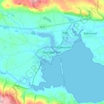
Dungarvan topographic map
Interactive map
Click on the map to display elevation.
About this map
Name: Dungarvan topographic map, elevation, terrain.
Average elevation: 98 ft
Minimum elevation: -7 ft
Maximum elevation: 699 ft
Other topographic maps
Click on a map to view its topography, its elevation and its terrain.
Lismore
Lismore, The Municipal District of Dungarvan — Lismore, County Waterford, Munster, P51 VW44, Ireland
Average elevation: 125 ft
St. Stephen's Within
Ireland > County Waterford > Waterford
St. Stephen's Within, Centre B, Waterford, County Waterford, Munster, Ireland
Average elevation: 85 ft
Mahon Falls
Mahon Falls, Mahon Falls Walk, Comeragh, The Municipal District of Comeragh, County Waterford, Munster, Ireland
Average elevation: 1,886 ft
Crotty's Rock
Crotty's Rock, Ross, The Municipal District of Comeragh, County Waterford, Munster, Ireland
Average elevation: 1,391 ft
Millstreet
Millstreet, Ballynamult, The Municipal District of Dungarvan — Lismore, County Waterford, Munster, Ireland
Average elevation: 367 ft
Park
Ireland > County Waterford > Waterford
Park, Waterford, County Waterford, Munster, Ireland
Average elevation: 72 ft
Portlaw
Portlaw, The Municipal District of Comeragh, County Waterford, Munster, Ireland
Average elevation: 249 ft
Waterford City Metropolitan District
Waterford City Metropolitan District, County Waterford, Munster, Ireland
Average elevation: 95 ft
Waterford
Waterford, County Waterford, Munster, Ireland
Average elevation: 108 ft
County Waterford
County Waterford, Munster, Ireland
Average elevation: 282 ft