
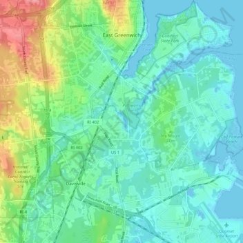
East Greenwich topographic map
Interactive map
Click on the map to display elevation.
About this map
Name: East Greenwich topographic map, elevation, terrain.
Average elevation: 69 ft
Minimum elevation: -20 ft
Maximum elevation: 282 ft
Other topographic maps
Click on a map to view its topography, its elevation and its terrain.
Warwick
United States > Rhode Island > Kent County
Warwick, Kent County, Rhode Island, United States
Average elevation: 52 ft
West Warwick
United States > Rhode Island > Kent County
West Warwick, Kent County, Rhode Island, United States
Average elevation: 194 ft
Masonic - Shriners Family Center
United States > Rhode Island > Kent County > Warwick
Masonic - Shriners Family Center, Warwick, Kent County, Rhode Island, United States
Average elevation: 23 ft
West Warwick
United States > Rhode Island > Kent County
West Warwick, Kent County, Rhode Island, 02893, United States
Average elevation: 197 ft
Coventry
United States > Rhode Island > Kent County
Coventry, Kent County, Rhode Island, United States
Average elevation: 413 ft
Hell's Half Acre
United States > Rhode Island > Kent County > West Greenwich
Hell's Half Acre, West Greenwich, Kent County, Rhode Island, 02822, United States
Average elevation: 361 ft
Crompton
United States > Rhode Island > Kent County > West Warwick
Crompton, West Warwick, Kent County, Rhode Island, 02893, United States
Average elevation: 207 ft
Greene
United States > Rhode Island > Kent County > Coventry > Greene
Greene, Coventry, Kent County, Rhode Island, 02827, United States
Average elevation: 456 ft
West Greenwich
United States > Rhode Island > Kent County
West Greenwich, Kent County, Rhode Island, 02817, United States
Average elevation: 364 ft