
Ringing Rocks topographic map
Interactive map
Click on the map to display elevation.
About this map
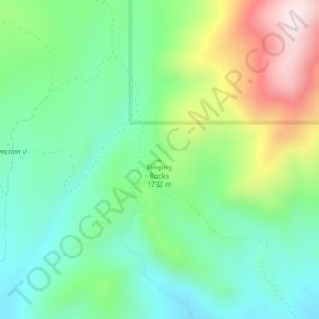
Name: Ringing Rocks topographic map, elevation, terrain.
Location: Ringing Rocks, Jefferson County, Montana, United States (45.94379 -112.23903 45.94389 -112.23893)
Average elevation: 5,584 ft
Minimum elevation: 5,013 ft
Maximum elevation: 6,745 ft
Other topographic maps
Click on a map to view its topography, its elevation and its terrain.
Clancy
United States > Montana > Jefferson County
Clancy, Jefferson County, Montana, 59638, United States
Average elevation: 4,495 ft
Rice Motel and Trailer Court
United States > Montana > Jefferson County > Whitehall
Rice Motel and Trailer Court, Whitehall, Jefferson County, Montana, United States
Average elevation: 4,390 ft
Welch
United States > Montana > Jefferson County
Welch, Jefferson County, Montana, United States
Average elevation: 5,610 ft
Boulder River
United States > Montana > Jefferson County > Boulder
Boulder River, Boulder, Jefferson County, Montana, 59631, United States
Average elevation: 6,450 ft
Mount Pisgah
United States > Montana > Jefferson County
Mount Pisgah, Jefferson County, Montana, United States
Average elevation: 7,431 ft
Whitehall
United States > Montana > Jefferson County
Whitehall, Jefferson County, Montana, United States
Average elevation: 4,383 ft
Montana City
United States > Montana > Jefferson County
Montana City, Jefferson County, Montana, 59634, United States
Average elevation: 4,400 ft